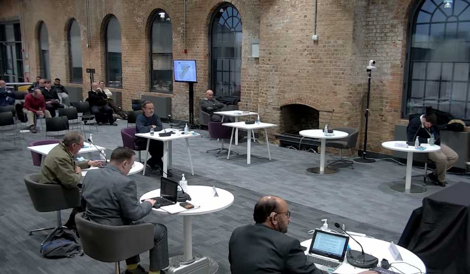
The 264 home for planning application the Tanholt Farm development went before planners on the 25 January 2022. Despite over 350 objections to the development including objections from Eye Parish Council, Ward Councillors and our MP due to its size and location, it was approved seven votes to three.
Resident Dale McKean who had previously objected by email was given just over five minutes to give a summary of his objections at the meeting. You can find all his objections in full below and in PDF format here.
This first section is a list of summaries from my presentation, the details, photos and references supporting them are in the next section.
Residential Travel Plan C24 – Summary
LP40 states The Transport Assessment Plan and Travel Plan need to be completed with all information with no reserve matters at Outline Planning Stage, without this site layout and housing impact cannot be done, this information eg Highways requests, Cycle LTN-20 policy, visibility splays needs to be resubmitted before approval of this Outline Planning application.
The developers Movement Strategy Plan shows that the current ROW will be unchanged, this will not comply with IDB Main Drain Easement requests and will not comply with PCC footpath/Cycleway policies and needs to be resubmitted. This change will also impact the housing numbers.
Drainage C15 Summary
The IDB have raised a number of important Issues for their Main Drain running through this site, including moving ROW/Footpath/Cycle Way and the tree line beyond the 9Mtrs easement area either side of the drain.
IDB have removed there objection based on replies from developer that this would be resolved at detail planning stage. This needs to be resolved at Outline Planning stage as per LP40. This means there is an overdevelopment of the site and the changes needed will therefore reduce the area available for houses.
Currently the dyke adjacent to the school playing fields does not go into the main drain on the site and as such it floods during the winter (as identified in Larkfleets Archaeological Assessment Mar 2018) This currently floods the school playing fields and the future houses around will also be water logged. If this is fed into the nearby SUDs then the play area in them will be flooded. A resolution is not included in the developer’s drainage plans.
Foul Water Drainage C16 Summary
The line of the Anglian Water assets has not been put in the Master plan so POS, Road layouts and impact on housing numbers cannot be verified. A rework of the Master plan documents is needed for the assets impacts. A condition needs adding for the essential offsite sewers works to be completed before first occupation.
Open Space Provision Summary – C17
The Council Landscape Officers has strongly objected to the Open Space proposal and requested a number of changes to the various provision (that had already been discussed with the developer) and have not been actioned these include:-
- Single large area of Public Open Space (POS) (not fragmented as currently shown) suitable for informal recreational activities such as football, cricket etc (referring Manor Farm Park Eye as a suitable example).
- There should be no ponds and SUDs should not be used as Open Space or have the LEAP in them.
This is an overdevelopment of the site at the expense of Public Open Space and Natural Green Space which has been incorrectly allocated around the site as per the Issues raised as well as the 9Mtrs easement areas both sides of the main IDB drain. Clearly the rework and new POS allocations will mean a reduce area for houses on this site.
C25 and C26 The works to Eyebury Road and Site Access
The site entrance is shown as a T Junction, this needs to be traffic lights as due to the high level of traffic down Eyebury Rd residents will not be able to get out of the site in the morning rush hour also this will be the same for anyone dropping of their children to the school drop of area leading to residents causing parking Issues on Eyebury Rd / Little Close rather than get stuck in the new estate trying to get out.
C28 Adequate space shall be provided within the site for parking
The roads need to have raised kerbs as the previous site on Bath Rd with a low kerb ended up with Cars parked on the footpaths.
Highway condition and safety – C30 Summary
The Traffic Survey data is incomplete as it was undertaken during Covid Lockdown step 3 in Jul 21 and working from home in Jul 21 and did not include Eyebury Rd outside the school. This needs repeating, reviewing and impacts added to the Transport Assessment and Travel Plans. PCC Highways Officers have objected to the application (letter dated 22/9/21) on a number of issues.
They have also concluded that there is no opportunity to mitigate the impact of the extra vehicle journeys. Officer’s state in this report, The Travel Plan and the mitigation measures to improve pedestrian and cycle access within and beyond the site will encourage travel by a choice of means of transport which will help to minimise car journeys. The suggested mitigation of a Cycleway on Thorney Rd will not work as Eye is a village away from the employment areas so residents will need to use their cars, the house numbers need to be 250 or less as per LP40. If the number of houses is not reduced then due to the many Issues raised this application should be rejected as it does not meet LP40 requirements.
C31 safe means of access and cycleway completion
C31-1 Road and cycleway need to be completed to surface level condition up to the School entrance before any residence is occupied.
C31-2 Larkfleets own safety Audit Stage 1 of BWB Transport Assessment Addendum actions 2.4 & 2.5 need resolving these being:-
- 2.4 Lighting levels along Eyebury Rd new zebra crossing and traffic calming features
- 2.5 Cycleway from the site does not tie into existing cycleways along Eyebury Rd leading to a risk of collision with pedestrians or falling into the path of oncoming vehicles.
Peterborough Cycle Forum C31 Summary
In Nov 21 Peterborough Cycle Forum although supportive has raised a significant number of Issues of the Cycle path and Public Right of Way design and widths to 2mtr footway and 3Mtr Cycle path on-site, household storage facilities and the design of the proposed cycle path along Thorney Rd to High Street to meet LTN 1-20 which supersedes Council policies. Such changes will impact the amount of area for housing so plans need to such be updated at Outline Planning Stage to reflect this.
Other Issues to be considered that may need conditions adding
- The Construction Management Plan (CMP) condition should have a mandatory access to the site to be from the direction Oxney Rd rather than Eyebury Rd that has a weight limit and unsuitable for construction traffic and has the school, pre-school and after school wrap around facility.
- There should be no parking of construction and delivery vehicles off-site.
- The Public Right of way should be safely open throughout the development with suitable fencing from the building sites.
- Eye School is already full and has a waiting list, it is about to have temporary classrooms, however, the land allocated to the school is not enough for its permanent expansion and the children drop off parking facility.
- The range of types and tenures do not respect the surrounding context and residents (Village needs bungalows, 3/4/5 bedroom houses and another elderly supported living 2 story complex).
- The latest Master Plan submitted by the developers has been changed for road, drainage and green space layouts, but this has not been updated with the housing layout and types so it cannot be reviewed for its housing suitability which should be done at this outline planning stage (LP40).
- The quality of life of adjacent residential users including the Residential Care Home and Primary School are not respected and there is no plan put forward for the 3 years duration to build this development.
- Proposed access points for pedestrians and cyclists are not available because the Council have not adopted the locations.
- The Doctors in Eye is at capacity and there is no plan and timescales to show how the surgery and parking will be expanded to accommodate the new residents.
- The Developer states trees and hedgerows are off-site yet they are within the boundary so will need to be maintained by the residents’ management and financial plan.
- The governance of the site facilities and the plan for them is not clearly defined During the preparation and consultation of the PCC Local Plan all sites put forward by developers had a sustainability and deliverability assessment review and for Eyebury Rd (LP39) the developers put forward 250 houses which passed the assessment.
Can I ask committee members to arrange resolution of all these Issues at this Outline Planning Stage as per the Council Policy LP40 for this specific site and that the site is reduced to 250 or less as per policy LP40 because of the Issues raised. I have added suggested conditions in my detail report below as well.
==================================================================
Councillors, you could make a significant difference to the future residents and their children of this site along with the villagers of Eye and their children attending Eye primary school next to the site.
Due to the significant concerns about this site and the impact on the infrastructure and facilities raised by residents our Councillors/MP and Parish Council a specific.
Local Plan Policy LP40 was added by the City Council Planners and approved by the Inspector.
For this application to comply with Policy LP40 at Outline Planning stage, a number of Issues remain in the report to you and raised by Council Officers and a statutory body (The IDB).
So I request that additional conditions raised in my presentation be applied and very importantly the site is reduced to 250 or less as per policy LP 40.
C15 Drainage
Pasted below is an extract from Larkfleets supplied Archaeological desk based assessment pg 20 Doc Ref PCAS Job No. 1983 Dated Mar 2018 it shows a flooded ditch on edge of school in Feb 2018.
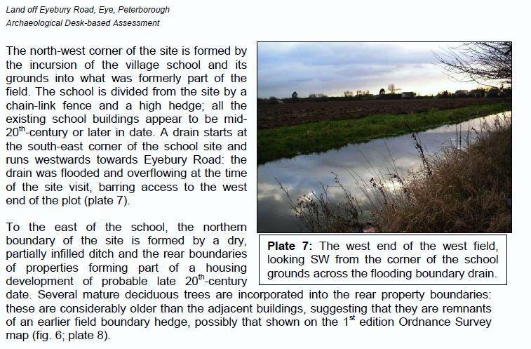
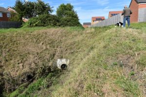
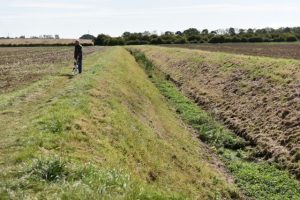
Currently, the drain adjacent to the school playing fields does not go into the main drain on the site and as such it floods during the winter and the school playing fields are waterlogged (see plate 7 above of drain in winter) and photos below taken in Sep 19. There is no detail in the plans on how to drain this water and provide drainage to the new vehicle park and playing fields within the school and for the new houses to be built next to it on the site.
If it is to be connected to the nearby SUD with the LEAP in it then this will flood and the children’s play area will be unusable.
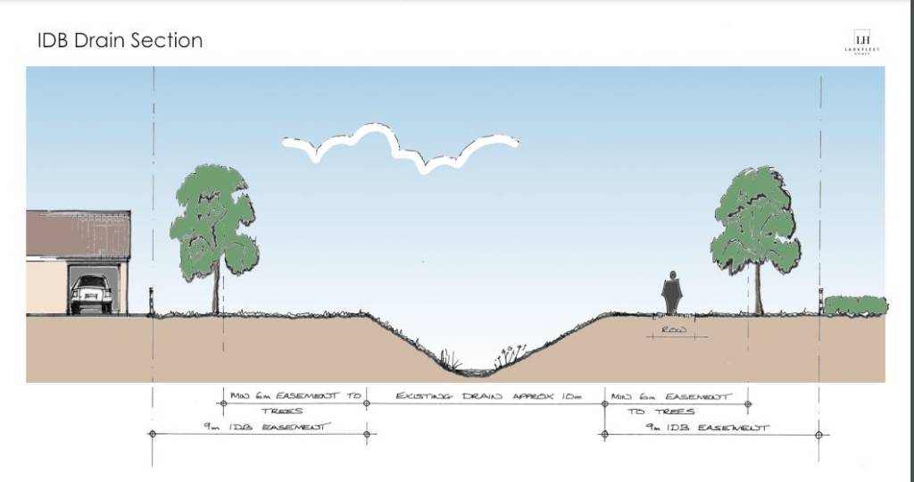
The Main Drain dissecting the site North to South owned by the IDB has a 9 Mtrs wide Easement area on both sides of it, this needs to be fenced off for safety of the residents and children.
Once done who will maintain the fenced of easement area?
The ROW and Cycle Path will need to be moved north of the 9Mtr easement (As raised by drainage Board on 22nd Aug 2019 & Aug 2021) for safety and it will need to be a fully surfaced path and lit.
The Trees need to be moved to outside the 9Mtr easement area (As raised by drainage Board in Aug 2021).
Larkfleet Diagram 1/9/2021 for IDB Main Drain running through the site (does not comply with IDB requests).
Drainage C15 Summary
The IDB have raised a number of important Issues for their Main Drain running through this site, including moving ROW/Footpath/Cycle Way and the tree line beyond the 9Mtrs easement area either side of the drain.
IDB has removed their objection based on replies from the developer that this would be resolved at detail planning stage. This needs to be resolved at the Outline Planning stage as per LP40.
This means there is an overdevelopment of the site and the changes needed will therefore reduce the area available for houses.
Currently the dyke adjacent to the school playing fields does not go into the main drain on the site and as such it floods during the winter (as identified in Larkfleets Archaeological Assessment Mar 2018). This currently floods the school playing fields and the future houses around will also be water logged. If this is fed into the nearby SUDs then the play area in them will be flooded. A resolution is not included in the developer’s drainage plans.
C16 Foul Water Drainage
C16-1 Update the Site Master Plan documents for the impact of the following Anglian Water has also confirmed that there are assets or those subject to an adoption agreement within or close to the development boundary that may affect the layout of the site. Therefore the detailed site layout should take this into account and accommodate those assets within either prospectively adoptable highways or public open space.
C16-2 Essential offsite sewers works to be completed before first occupation as per the following Anglian Waters Drainage Impact Assessment Report Ref.19597 dated 7th April 2017 on foul water only. The study concludes that the development will cause detrimental effects to the capacity of the current sewer system and will result in increased flood risk downstream of the proposed connection point.
Mitigation actions are require
1 – Upsize 112m length of 225mm diameter sewer to 650mm diameter situated on the corner of Eyebury Road and Little Close.
2 – Upsize 44m length of 300mm diameter sewer to 825mm diameter situated on St Michaels Walk near Eye – Little Close pumping station.
Foul Water Drainage C16 Summary
The line of the Anglian Water assets has not been put in the Master plan so POS, Road layouts and impact on housing numbers cannot be verified.
A rework of the Master plan documents is needed for the assets impacts.
A condition needs adding for the essential offsite sewers works to be completed before first occupation.
C17 Open Space Provision
In Jun 2021 PCC Senior Landscape Officer Strongly Objected to this proposal and requested a number of changes to the Open Space Provision (that had already been discussed with the developer) which I have added as further conditions below:-
C17-1 Create a single large area of Public Open Space (POS) (not fragmented as currently shown) suitable for informal recreational activities such as football, cricket etc (referring Manor Farm Park Eye as a suitable example).
C17-2 That Master Plan Diagram indicates edges of roads are Public Open Space or Natural Green Space, they cannot be used as such for informal recreation.
C17-3 There should be no Dry Ponds on the site. NOTE Oct 21 Rev E Indicative Master Plan still shows 3 ponds and 3 SUDs (one being in the LEAP) in the POS allocated, but these are not shown in Oct 21 Rev A Indicative POS Indicative plan ! Additional the Drainage Strategy Documents sent to the IDB indicate 2 of the ponds will be 1.5Mtrs deep, including the one at the SLEAP and the 3rd pond will be 1 Mtr deep. Clearly if there are 3 SUDs and 3 Ponds then more POS needs allocating in the site. Or they should be removed as requested by Landscape Officer if removed how would it affect site drainage and the IDB consultation assessment.
Additional conditions
C17-4 The Drainage Border easement area is 9Mtrs either side of the main drain, this needs fencing off for safety and therefore cannot be included as Public Open Space or Natural Green Space.
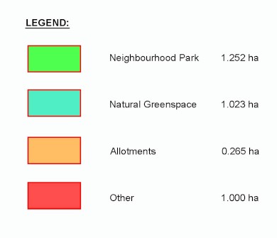
C17-5 The Drainage Border easement area is 9Mtrs either side of the main drain is shown in Indicative POS area map Rev A Dated 211021 as Natural Green Space of a 1.023 Hectare and trees planted on it, clearly this cannot be allocated as such as it will be having IDB Machining using it to maintain the clearance of the main drain as well as depositing silt onto. Therefore another area of the site needs allocating for the 1 hectare of Green Space
C17-6 Developer to rework and resubmit Site Layout, POS and Housing Master Plans Due to
Issues raised above needing a significant rework of them.
C17-7 Remove the Planning Officers condition statement for Open Space provision (pasted below) – The plans and particulars to be submitted for reserved matters approval under condition 1 shall include details of open space provision which shall broadly accord with the amount of open space shown on Drawings L—/MP/01 Rev.E – Indicative Masterplan and L—/POS/01 Rev.A – Indicative POS areas and include a LEAP and allotments.
Open Space Provision Summary – C17
The Council Landscape Officers has strongly objected to the Open Space proposal and requested a number of changes to the various provision (that had already been discussed with the developer) and have not been actioned these include:-
- Single large area of Public Open Space (POS) (not fragmented as currently shown) suitable for informal recreational activities such as football, cricket etc (referring Manor Farm Park Eye as a suitable example)
- There should be no ponds and SUDs should not be used as Open Space or have the LEAP in them.
This is an overdevelopment of the site at the expense of Public Open Space and Natural Green Space which has been incorrectly allocated around the site as per the Issues raised as well as the 9Mtrs easement areas both sides of the main IDB drain. Clearly the rework and new POS allocations will mean a reduce area for houses on this site.See Appendix of Larkfleet developer Indicative Master Plans below.
C17 Appendix 1 – Developers Diagrams:-
Indicative Master Plan Oct 21 Rev E
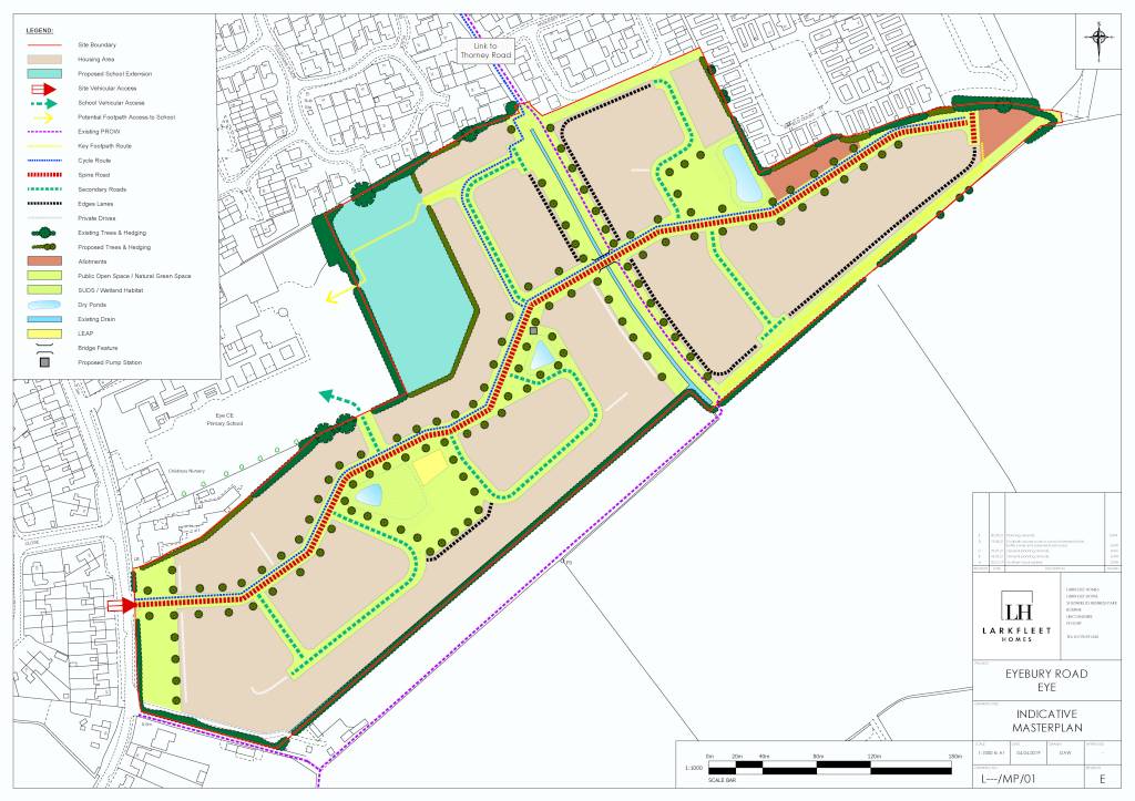
Key for Indicative Master Plan Oct 21 Rev E (above)
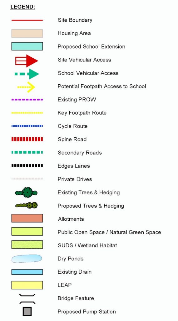
Indicative POS Area Map Oct 21 Rev A
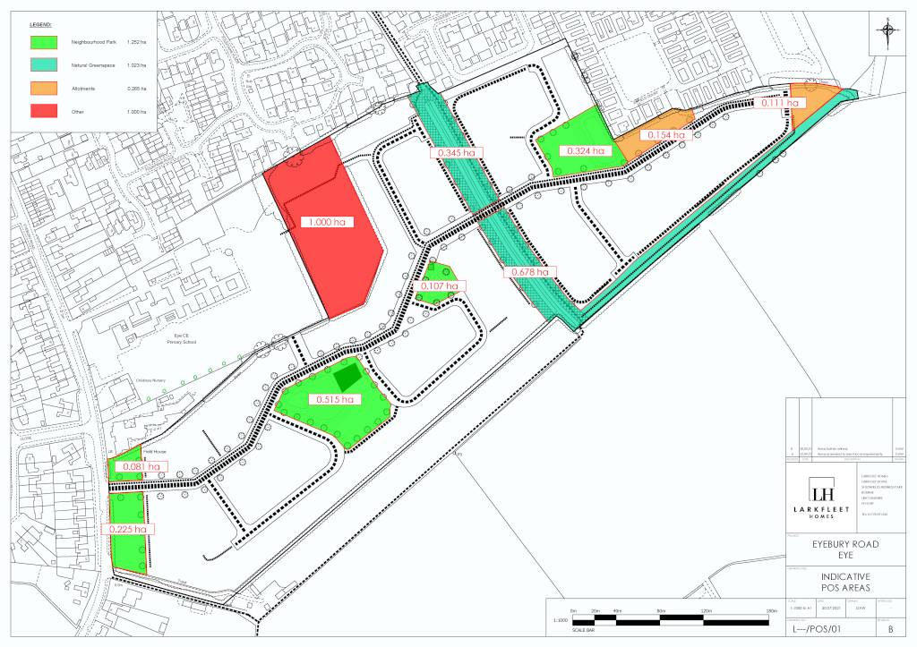
Key for Indicative POS Area Map Oct 21 Rev A
C24 Residential Travel Plan
C24-1 The developers Movement Strategy Plan shows that the current ROW will be unchanged, a condition is needed to :-
Move the ROW north of the drain easement distance of 9Mtrs. As this will be a footpath as well as cycle way it should be a fully surfaced path and 5 Mtrs wide. And for safety it should be lit.
C24-2 LP40 is clear that at Outline Planning stage the Transport Assessment and Travel Plan needs to demonstrate that the quantity of homes proposed ‘is deliverable taking account of; safe and suitable access to the site; and cost effective and necessary improvements to the transport network.’
The developer in a number of Transport/Travel documents have deferred detail as reserved matters and also challenged the need to supply detail at outline planning. This means comments by all consultees as to volume of houses and site layout is not able to be completed and does not conform to LP40 (see below).
Extracts from BWB Revised Transport Assessment 2 Aug 21 Addendum 2:-
‘2.2 In summary, some of the detail has been removed from the masterplan seeing as the application is in outline form and so the scheme proposals are primarily indicative at this stage of the process. ‘
1. Update the proposals to take account of LTN 1/20 – a cycle route is proposed on the northern side of the main site access spine road, and the contents of this document will be considered in further detail at the appropriate time, as part of the subsequent reserved matters planning applications.
5. Consider the impacts of the required visibility splays on the layout to determine whether the site can accommodate the number of dwellings proposed – this would be examined in further detail at the appropriate time, as part of the subsequent reserved matters planning applications. Larkfleet are challenging Highways request for detailed layout quoting ‘We note that on other outline applications the LHA and the LPA have agreed that such matters of detail can be left to the reserve matters stage. I trust that can be done in this case as well.’ – Other applications do not have to conform to LP40 so these details need to be supplied as part of this outline application.
Residential Travel Plan C24 – Summary
LP 40 states The Transport Assessment Plan and Travel Plan need to be completed with all information with no reserve matters at Outline Planning Stage, without this site layout and housing impact cannot be done, this information eg Highways requests, Cycle LTN-20 policy, Visibility splays needs to be resubmitted before approval of this Outline Planning application. The developers Movement Strategy Plan shows that the current ROW will be unchanged, this will not comply with IDB Main Drain Easement requests and will not comply with PCC footpath/Cycle way policies and needs to be resubmitted. This change will also impact the housing numbers.
C25 and C26 The works to Eyebury Road and Site Access
The site entrance is shown as a T Junction, this needs to be traffic lights as due to the high level of traffic down Eyebury Rd residents will not be able to get out of the site in the morning rush hour also this will be the same for anyone dropping of their children to the school drop of area leading to residents causing parking Issues on Eyebury Rd / Little Close rather then get stuck in the new estate trying to get out.
C28 Adequate space shall be provided within the site for parking
C28-1 The roads need to have raised kerbs as previous site on Bath Rd with low kerb ended up with Cars parked on the footpaths.
C30 Highway condition and safety
- C30-1 Eyebury Rd had a weight restriction added many years ago because heavy traffic was damaging the water supply and drainage systems leading to leaks, there for all site access traffic should use Oxney Road
- C30-2 Due to the current significant parking Issues and safety of the children attending the school, No parking of site staff vehicles on Eyebury Rd and its surrounding streets
- C30-3 The Council Highways department have objected to the application (letter dated 22/9/21). These are the reasons notified for the objection
Ensure that safe access to and from the cycleway for cyclists travelling in both directions is provided in the vicinity of the site access. Show the provision of the adoptable cycleway through the site and up to Thorney Road. Provide the highway mitigation measures (sustainable travel improvements and measures to encourage the use of sustainable modes) identified as a result of the TA information, and the lack of mitigation available for vehicular traffic
Also there are many Assessment / Comments in the PCC Highways letter of objection - C30-4 PCC and there consultants have analysed Larkfleets Traffic Assessment reports, PCC Highways have stated there currently is no opportunity to mitigate the traffic impact from the new development on surrounding roads and junctions, e.g. A47 Trunk Road and A1139 and there roundabouts. So the current Issues of high volume traffic past the adjacent school and past the site entrance will get worse due to the extra vehicles from the development. LP40 states a quantity of 250 houses or less dependent on Traffic Assessment. So the site should be reduced to less than 250 houses
- The suggested mitigation of a Cycle way on Thorney Rd and improvements to the 2 bus stops will not work as Eye is a village away from the employment areas so residents will need to use their cars, there for house numbers need to be 250 or less as per LP40
- C30-5 The Junction validation technical note date 20/07/2021 this was a drive by traffic surveys of junctions undertaken AM & PM in peak hours on the 8th July 21. On the 8th July the Country was still in Step 3 lockdown including working from home with a target on moving to step 4 on the 19th July.
Clearly any traffic assessment taken on the 8th Jul 2021 would not represent the true figures due to Covid Step 3 lockdown and working from home rules. This traffic assessment did not include the areas outside the school on Eyebury Rd in the morning drop off and afternoon collection, the most significant road traffic Issue the village has.
LP40 is clear that the Transport Assessment and Travel Plan needs to demonstrate that the quantity of homes proposed ‘is deliverable taking account of; safe and suitable access to the site; and cost effective and necessary improvements to the transport network.’ There for accurate traffic surveys need to be resubmitted before approval of this Outline planning application is given.
Highway condition and safety – C30 Summary
The Traffic Survey data is incomplete as it was undertaken during Covid Lockdown step 3 in Jul 21 and working from home in Jul 21 and did not include Eyebury Rd outside the school. This needs repeating, reviewing and impacts added to the Transport Assessment and Travel Plans. PCC Highways Officers have objected to the application (letter dated 22/9/21) on a number of issues.
They have also concluded that there is no opportunity to mitigate the impact of the extra vehicle journeys.
Officer’s state in this report, The Travel Plan and the mitigation measures to improve pedestrian and cycle access within and beyond the site will encourage travel by a choice of means of transport which will help to minimise car journeys.
The suggested mitigation of a Cycle way on Thorney Rd will not work as Eye is a village away from the employment areas so residents will need to use their cars, there for house numbers need to be 250 or less as per LP40.
If the number of houses is not reduced then due to the many Issues raised this application should be rejected as it does not meet LP40 requirements.
C31 safe means of access road and cycle way completion
C31-1 Road and cycle way need to be completed to surface level condition up to the School entrance before any residence is occupied
C31-2 Larkfleets own safety Audit Stage 1 of BWB Transport Assessment Addendum actions 2.4 & 2.5 need resolving these being :-
2.4 Lighting levels along Eyebury Rd new zebra crossing and traffic calming features
2.5 Cycleway from the site does not tie into existing cycle ways along Eyebury Rd leading to a risk of collision with pedestrians or falling into the path of oncoming vehicles.
C31-3 Peterborough Cycle Forum although supportive has raised the following 11th Nov
2021
The plans show 3m wide shared use cycle-paths , cycles must be treated as vehicles and not as pedestrians and On urban streets, cyclists must be physically separated from pedestrians and should not share space with pedestrians for new development on a greenfield site (LTN 1-20, section 1.6).
Shared use may be acceptable on paths with very low pedestrian and cyclist flows but it is not appropriate on a route used for travel to and from a primary school. Peterborough Cycle Forum requests the proposed 3m wide shared use routes within the development and the shared use link to Thorney Road are replaced by a segregated 2m wide footway and 3m wide bidirectional cycle route.
A minimum of one cycle parking space per bedroom should be provided (LTN 1-20, Table 11-1) and a minimum area of 2m x 1m is required for two cycles. Peterborough Cycle Forum requests confirmation that residential cycle parking will be provided in line with the standards of LTN 1-20
Peterborough Cycle Forum C31 Summary
In Nov 21 Peterborough Cycle Forum although supportive has raised a significant number of Issues of the Cycle path and Public Right of Way design and widths to 2mtr footway and 3Mtr Cycle path on site, household storage facilities and the design of the proposed cycle path along Thorney Rd to High Street to meet LTN 1-20 which supersedes Council policies. Such changes will impact the amount of area for housing so plans need to such be updated at Outline Planning Stage to reflect this.
For reference – Policy LP40: Tanholt Farm, Eye states:
Prior to the approval of detailed proposals for the site at Tanholt Farm, Eye (Site LP39.7) an outline planning application comprising, amongst other matters, a comprehensive masterplan for the whole area should be submitted and approved by the council. In developing the masterplan there should be a high level of engagement with appropriate stakeholders including the local community.
The masterplan, together with other material submitted with an outline planning application, should demonstrate achieving the following key principles:
- The scale of residential development will be subject to a detailed Transport Assessment and Travel Plan which will demonstrate that the quantity of homes proposed is deliverable taking account of; safe and suitable access to the site; and cost effective and necessary improvements to the transport network. It is anticipated that the scale will be around 250 dwellings, but potentially less following the outcome of the transport assessment;
- A residential led scheme, of a range of types and tenures that meet needs and respects the surrounding context;
- The quality of life of adjacent users, especially residential users which abut the site, should be respected;
- Details of the long term governance structure for the development, addressing issues such as community involvement and engagement and any financial arrangements to ensure long term viability of facilities;
- Ensuring satisfactory provision of education facilities are available, and if not, address these deficiencies on-site;
- Provision, including potential off-site provision (secured by legal agreement), of high quality access for pedestrians and cyclists from, and within, the site to the key community facilities and services in Eye;
- Provision of wider community facilities as identified through consultation with the wider Eye community (subject to viability, deliverability and consideration of long term management of such facilities)
- With the exception of minor proposals of very limited consequence to the overall redevelopment of the entire site, the council will not approve any detailed planning proposals for any parts of the site until, and subsequently in accordance with, a comprehensive planning permission for the entire site has been achieved (including any agreed Planning Obligation to ensure specific elements of the wider scheme are guaranteed to be delivered).

